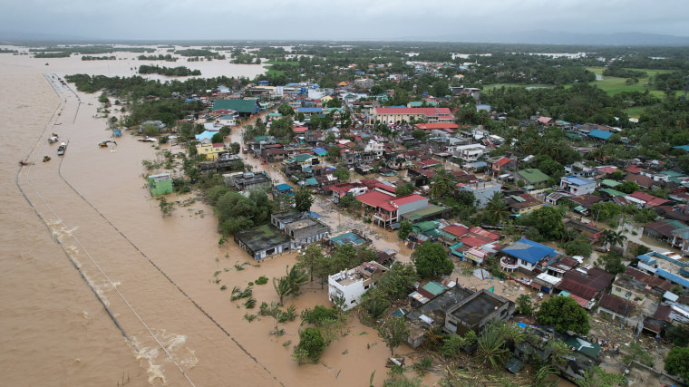
As Tropical Storm Nokaen moves across parts of the Philippines, disaster authorities have raised alerts over a dangerous secondary hazard: lahars—fast-moving flows of volcanic mud, ash, and debris—around the slopes of Mayon Volcano in the Bicol region. While storms bring heavy rain and flooding, in volcanic landscapes they also awaken a far more destructive force, capable of sweeping away homes, roads, farms, and lives.
The combination of recent volcanic ash deposits and intense rainfall has created ideal conditions for lahar formation, putting communities near Mayon on high alert. This article explains what lahars are, why Tropical Storm Nokaen makes them more likely, how authorities are responding, and what this means for disaster preparedness in one of the world’s most hazard-prone countries.
Understanding the Threat: What Is a Lahar?
A lahar is a mixture of water, volcanic ash, rock fragments, and debris that flows rapidly downhill, often following river channels and valleys. Unlike slow landslides, lahars can move as fast as a racing car and travel many kilometers from a volcano.
Lahars can be triggered by:
- Heavy rainfall on loose volcanic ash
- Typhoons or tropical storms
- Melting snow or ice (in colder regions)
- Volcanic eruptions followed by rain
In tropical countries like the Philippines, rain-induced lahars are the most common.
Why Lahars Are So Dangerous
Lahars are extremely destructive because they:
- Carry massive boulders and debris
- Bury homes and farmland under thick mud
- Destroy bridges, roads, and utilities
- Give very little warning before striking
They can occur even when a volcano is not actively erupting, making them a hidden but deadly risk.
Mayon Volcano: Beauty and Danger Side by Side
Mayon Volcano, located in Albay province in the Bicol region, is famous for its near-perfect cone shape. It is also one of the most active volcanoes in the Philippines.
Key facts about Mayon:
- One of the country’s most frequently erupting volcanoes
- Surrounded by densely populated communities
- Produces large amounts of ash during eruptions
- Has a long history of destructive lahars
After eruptions or periods of activity, volcanic ash and debris accumulate on its slopes. When heavy rains arrive, this loose material is easily washed downhill, forming lahars.
How Tropical Storm Nokaen Increases Lahar Risk
Heavy Rainfall as a Trigger
Tropical Storm Nokaen has brought:
- Intense and prolonged rainfall
- Flooding in low-lying areas
- Saturation of volcanic slopes
When rainwater mixes with ash and loose rock on Mayon’s slopes, it forms thick, fast-moving mudflows.
The more intense and continuous the rain, the higher the lahar risk.
Rivers Become Highways for Lahars
Lahars usually follow:
- Dry riverbeds
- Drainage channels
- Gullies formed by past flows
During storms, these channels fill rapidly, carrying volcanic debris straight into towns and farmland.
Areas at Risk Around Mayon
Communities living near:
- River valleys
- Low-lying slopes
- Areas with past lahar history
are especially vulnerable.
High-risk zones include:
- Villages along major river systems draining Mayon
- Farming communities near volcanic slopes
- Areas where ash deposits are thick
Even people far from the crater can be hit if they live along lahar pathways.
Lessons from the Past: Lahar Disasters in the Philippines
The Philippines has experienced devastating lahar disasters before.
One of the worst examples occurred after the eruption of Mount Pinatubo in the 1990s, when:
- Years of heavy rain triggered repeated lahars
- Entire towns were buried
- Thousands of families were displaced
Mayon itself has a long history of lahar-related destruction, especially after eruptions followed by typhoons or strong monsoon rains.
These past events show that:
- Lahars can be more destructive than eruptions
- Risk can last for years after volcanic activity
- Preparation is critical
Government and Disaster Agency Response
Early Warning Systems
Authorities in the Philippines rely on:
- Rainfall monitoring
- River level sensors
- Volcanic ash tracking
- Community-based alert systems
When rainfall reaches dangerous levels, warnings are issued for possible lahar formation.
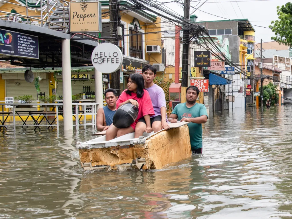
Evacuation and Safety Measures
With Tropical Storm Nokaen approaching, officials have:
- Identified high-risk villages
- Prepared evacuation centers
- Issued advisories to stay away from river channels
- Placed emergency teams on standby
Residents in danger zones are encouraged to:
- Evacuate early if advised
- Avoid crossing rivers
- Stay updated through official channels
Community Role in Lahar Preparedness
In areas near Mayon, local communities are trained to:
- Recognize early signs of lahars, such as rumbling sounds or sudden muddy water
- Respond quickly to evacuation orders
- Avoid returning too soon after heavy rain
Community volunteers often:
- Monitor river conditions
- Help elderly and children evacuate
- Coordinate with disaster agencies
Local awareness can mean the difference between life and death.
Environmental and Economic Impact of Lahars
Damage to Agriculture
Lahars often:
- Bury rice fields and farms
- Kill crops and livestock
- Destroy irrigation systems
For farming communities around Mayon, a single lahar event can wipe out an entire season’s income.
Infrastructure Destruction
Lahars can:
- Wash away roads and bridges
- Damage power and water lines
- Isolate villages for days or weeks
This slows rescue operations and economic recovery.
Long-Term Landscape Change
While destructive, lahars also:
- Change river courses
- Create new landforms
- Deposit fertile soil over time
In the long run, volcanic soil can be very productive—but the immediate cost is often tragic.
Why Climate Change Makes Lahar Risk Worse
Climate change is expected to:
- Increase rainfall intensity
- Strengthen tropical storms
- Cause more extreme weather events
This means:
- More frequent lahar triggers
- Less time for communities to recover between disasters
- Greater strain on disaster response systems
In volcanic regions like Bicol, climate change multiplies natural risks.
Technology and Science in Lahar Monitoring
Modern tools help reduce risk:
- Rain gauges and satellite data track storm intensity
- Volcanic monitoring stations measure ash deposits
- Drones and mapping tools identify lahar pathways
- SMS and radio alerts warn communities
However, technology works best when combined with:
- Strong local leadership
- Community training
- Trust in official warnings
What Residents Should Do During Lahar Alerts
Safety Guidelines
If you live near Mayon or similar volcanic areas:
- Stay away from rivers and channels during heavy rain
- Follow evacuation orders immediately
- Prepare emergency kits with food, water, medicine, and documents
- Listen to radio, local officials, or disaster agencies
- Do not return until authorities declare it safe
Lahars move quickly—waiting too long can be fatal.
Psychological and Social Effects
Repeated disasters affect not just land and buildings but people’s minds:
- Fear of losing homes again
- Stress during every storm
- Trauma from past disasters
Communities near Mayon live with constant risk. Support systems, counseling, and strong social bonds are essential for long-term resilience.
Tourism and Economic Concerns
Mayon is a major tourist attraction. However:
- Storms and lahar threats reduce tourism
- Businesses lose income during evacuations
- Travel restrictions affect local economies
Balancing safety and livelihood is a constant challenge for the region.
Why This Matters Beyond the Philippines
The situation around Mayon and Tropical Storm Nokaen shows a global reality:
- Natural hazards often combine—storm plus volcano, rain plus ash
- Climate change increases compound disasters
- Preparedness saves lives more than technology alone
Many countries with volcanoes and heavy rainfall face similar risks, making lessons from Mayon important worldwide.
The Bigger Picture: Living with Nature’s Power
The Philippines sits on the Pacific Ring of Fire and in the path of tropical storms. This means:
- Volcanic eruptions are part of life
- Typhoons are unavoidable
- Lahars are a recurring danger
The challenge is not to eliminate risk, but to:
- Understand it
- Respect it
- Prepare for it
Communities near Mayon have shown remarkable resilience through generations of disasters.
Conclusion
As Tropical Storm Nokaen brings heavy rain to the Philippines, the greatest danger near Mayon Volcano may not come from the sky, but from the mountains—through fast-moving, deadly lahars.
These mudflows, born from the meeting of rain and volcanic ash, can destroy lives and livelihoods in minutes. History has shown how devastating they can be, but it has also shown that early warnings, strong community action, and respect for nature’s power can save lives.
The lahar threat near Mayon is a reminder that disasters are rarely single events. They are often chains of hazards—storm, flood, mud, and ash—linked together. Facing them requires science, preparedness, cooperation, and courage.
For the people living under the shadow of Mayon, every storm is more than weather—it is a test of readiness, resilience, and hope.